Apache Peak, 13,441'
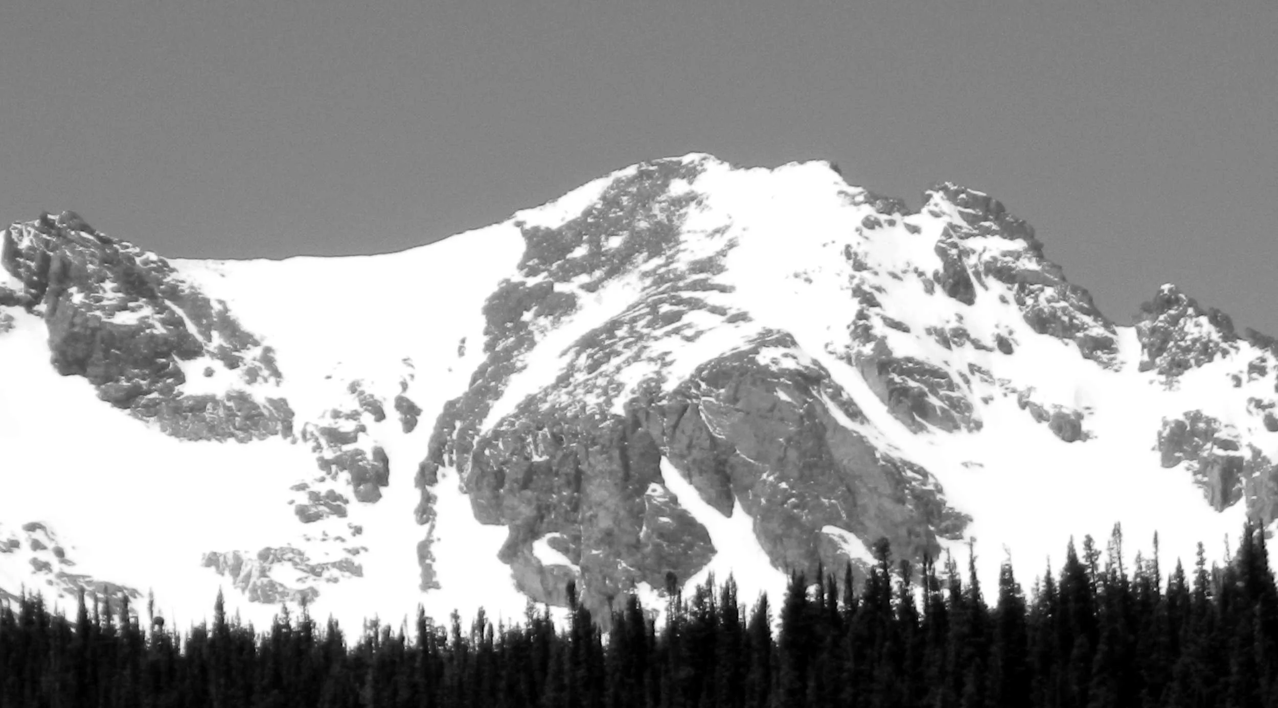
Navajo and Apache Peaks from the east. (N 1 is the Navajo Snowfield) Photo: Rob Writz
Apache Peak reigns supreme at the headwaters of the South Saint Vrain River and Cascade Creek. This high peak is flanked by snowfields on all sides: The Fair Glacier on the West, the Isabelle Glacier on the North, and the Navajo Snowfield to the south. Apache Peak captures everyone’s attention from the Brainard Lake area. It is the furthest peak from the Brainard Lake Gateway Trailhead, but when the access to the Long Lake Trailhead opens in mid-June there are still ample skiing opportunities in the basin hosting Apache, Shoshoni, and Navajo.
+ ROUTES
Routes 1 and 2 have a shared approach to the tarn at 11,440'
From the Long Lake Trailhead, ski or hike southwest about two tenths of a mile to Long Lake on the Pawnee Pass Trail. Follow the trail west, or the approximate path of the trail if snow covered, along the north side of Long Lake about 2 miles to Lake Isabelle. At Lake Isabelle, continue under a mile west on the north side of the Lake following the Isabelle Glacier Trail. If the lake is frozen solid it may be easier to ski across the lake, otherwise there are several steep walls on the north side of the lake that you will have to by-pass. Go about 1 mile west from the far shore of Lake Isabelle to the small tarn below Navajo, Apache, and Shoshoni Peaks at about 11,440'.
Route 1 - Apache Couloir
- Rating: III D12
- Season: Spring
- Exposure: East
- Vertical: 1,200'
- Approach Elevations: 10,080' - 13,441'
- Approach Distance: From Long Lake TH: 4.5 miles, From Brainard Lake Gateway TH: 8.5 miles
The inset Apache Couloir is one of the classic ski descents of the Indian Peaks. The snow will remain in the couloir in the summer, but the lower angle upper snowfields to the summit melt out in the spring. The winds of winter result in a thinner base higher up the peak. Hopefully, you can time this right to get a long descent from near the summit and into the steep couloir on consolidated spring snow. In May and June, a summit ski descent to the tarn at 11,440’ is a nearly 2,000’ descent. You can link snowfields to the shore of Lake Isabelle. This couloir faces directly east into the sun rising over the Great Plains, and is frequently climbed by snow mountaineers.
From the 11,440’ tarn described in the shared approach, deviate from the path of the Isabelle Glacier Trail and switchback southwest to a bench at 12,280' that puts the Isabelle Glacier to your north, Apache Couloir to the west, and Navajo Snowfield to the southwest. From here, continue directly west to the couloir.
Route 2 - Queens Way
- Rating: III D7
- Season: Spring, Summer
- Exposure: Northeast
- Vertical: 1,200’
- Approach Elevations: 10,080' - 13,441'
- Approach Distance: From Long Lake TH: 4.5 miles, From Brainard Lake Gateway TH: 8.5 miles
The Isabelle Glacier is a permanent snowfield on the northeast side of Apache Peak and the south side of Shoshoni Peak. Queens Way is a fun and broad couloir that extends from the Isabelle Glacier to the upper flanks of Apache Peak. If you want to ski this couloir from near the summit of Apache you need to time this with consolidated spring snow, but not too late in the spring because the upper snowfields that connect the summit to Queens Way to will melt out. The broader Isabelle Glacier is a great place to hang out and ski several laps. In May and June you can ski to the tarn at 11,440'.
If you hike in later in the summer, follow the Isabelle Glacier trail from the 11,440' tarn described in the shared approach to the glacier. If there is still a lot of snow, follow the approach described for the Apache Couloir towards the bench at 12,280'. Trend to the northwest below the cliffs and to the Queens Way Couloir.
+ TRAILHEAD
Brainard Lake Gateway Trailhead (10,000), Mitchell Lake Trailhead (10,480’)
Brainard Lake Gateway Trailhead is the access point to the Mitchell Lake and Long Lake Trailheads. The road from the Gateway Trailhead to Mitchell Lake and Long Lake may not be open to cars until mid-June. Because of this closure the spring and early summer ski adventures in the Brainard Lake area are launched from here. The spacious trailhead at the Gateway is host to a large gathering of backcountry skiers and mountaineers in the pre-dawn hours on spring weekends. When the road opens in mid-June there is an access fee into the Brainard Lake Recreation Area. Access the Brainard Lake Gateway Trailhead on Brainard Lake Drive west of the town of Ward on Highway 72.
Gear up and ski, hike or ride your bike to the Long Lake Trailhead. It is about 3.5 miles from the Gateway on the Brainard Lake Road to the right turn leading to the Mitchell Lake Trailhead and the Long Lake Trailhead. Go about one eighth of a mile up this road and turn left and go another quarter mile to Long Lake Trailhead (straight goes to the Mitchell Lake Trailhead). You can check the status of the Brainard Lake Road at the USFS Roosevelt National Forest Boulder Ranger District Road Status website.
+ MAPS & PICTURES
Below we have included a link to a Google interactive map and a curated list of photos of the mountain.

Clicking on map above will open interactive Google map website