Mount Flora 13,132'
Mount Flora from the Northeast. Photo: Rob Writz
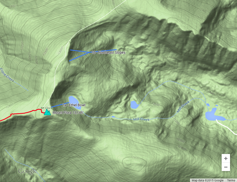
Mount Flora is an obscure 13er located on the Continental Divide north of Berthoud Pass. The mountain is quite accessible from the pass and the high trailhead plus the high vantage point makes Flora a great location for a quick excursion. The majority of the skiing is on the leeward side of the divide. The Ethel Bowl and Northeast Slopes consistently pull in the leeward snow and are a great ski! Make sure to budget time to climb back to the divide if you start at Berthoud Pass to ski the Ethel Bowl or Northeast Slopes. Flora and Robert Creeks drain the west side of Mount Flora to the Frasier River. These two drainages are best skied with full snow coverage as the exit to Highway 40 can be difficult without snow. Only a few Berthoud Pass winter skiers and splitboarders venture that far in the winter.
+ ROUTES
Routes
1 – Ethel Bowl and Northeast Slopes
- Rating: II D5 – D14
- Season: Spring
- Exposure: Northeast
- Vertical: 500’, 1,000’
- Approach Elevations: 11,300’ – 13,132’
- Approach Distance: From Berthoud Pass TH: 3.6 Miles
- Top of Route Waypoint: Ethel Bowl - 39.8056, -105.7359 | Northeast Slopes - 39.8108, -105.7335
Mount Flora has two northeast faces: Ethel Bowl and Northeast Slopes. Ethel Bowl is a steep shot that is guarded by overhanging cornices (1a, D11). It is difficult to see into the bowl if you have approached from Berthoud Pass. Overhanging cornices also rim the skier’s left side of the Northeast Slopes (1c, D14). The skier’s right side of the Northeast Slopes has an open and less steep entrance(1b, D5).
The most common approach is from Berthoud Pass. Follow the service road on the east side of the pass to just below Colorado Mines Peak. Alternatively, boot or skin directly up the old ski slopes to this same point. Head north and down Colorado Mines Peak and make the gentle climb to the summit of Mount Eva. The exit back to the Continental Divide is the blunt ridge separating Ethel Bowl and the Northeast Slopes.
+ TRAILHEAD
Berthoud Pass Summit (11,300’)
The summit of Berthoud Pass is the epicenter of backcountry skiing on this part of the Front Range. There is a large parking lot and a small building with restrooms and a warm room that you can use to gear up on cold day. The summit is on Highway 40 18 miles from Empire (near exit 232 on Interstate 70) and 11.3 miles on Highway 40 from Winter Park. [39.798, -105.7771]
+ MAPS & PICTURES
Below we have included a link to a Google interactive map and a curated list of photos of the mountain.

Clicking on map above will open interactive Google map website