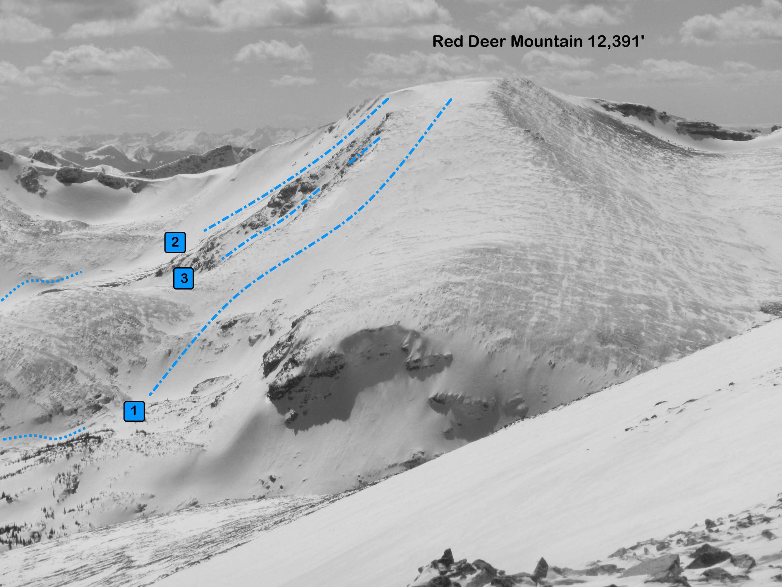
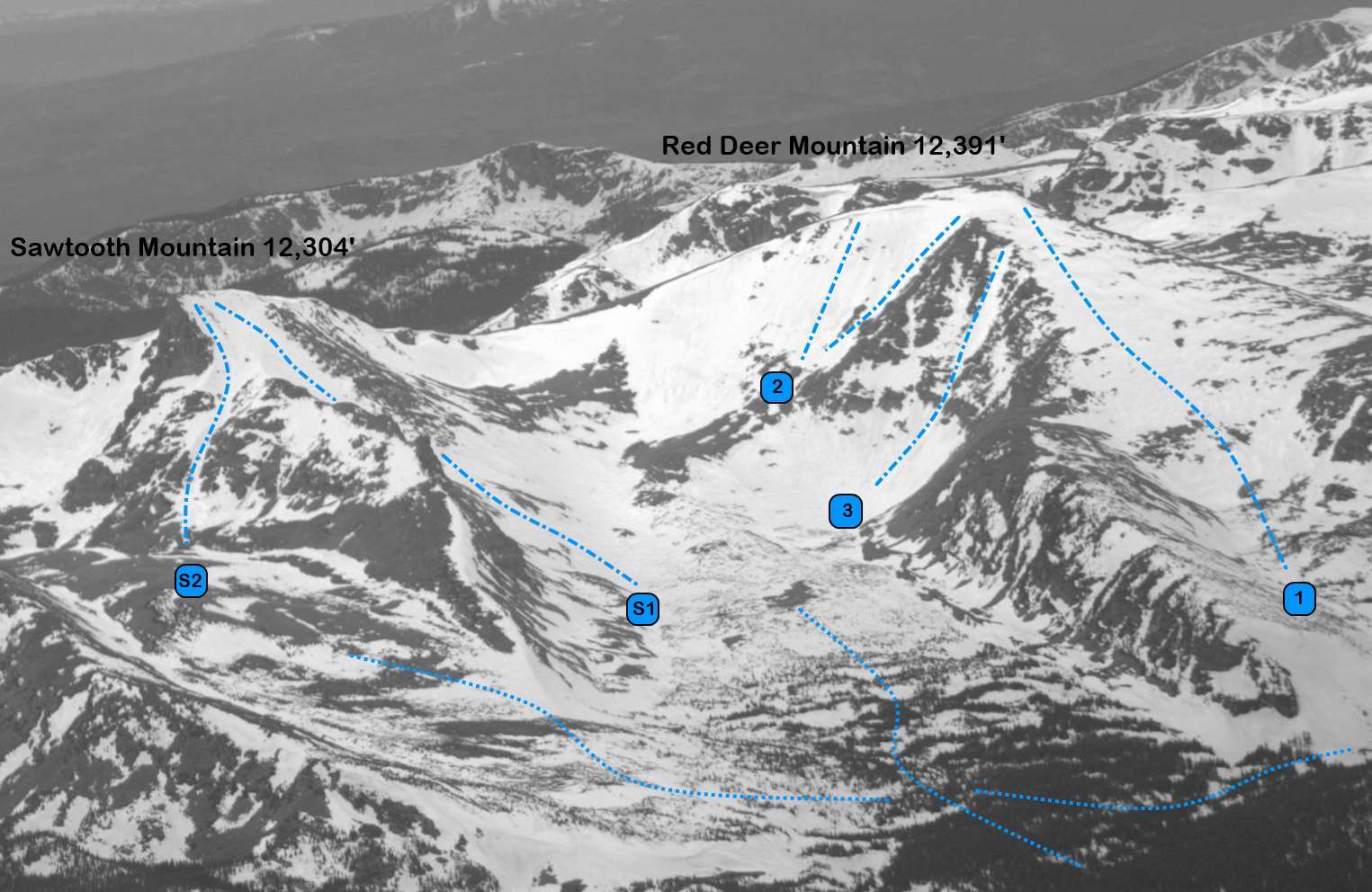
Red Deer Mountain 12,391'
Red Deer Mountain from Saint Vrain Mountain (north). Photo: Rob Writz
Point 12,391 or “Red Deer Mountain” stands between Sawtooth Mountain and the Saint Vrain Glaciers on the Continental Divide. The mountain is named after the lake that is below the East Slope. The Flatirons and other foothills block the view of Red Deer from the Denver area, but the mountain is distinctive from points on the Eastern Plains north of Boulder. Red Deer stands out in the spring because of the significant snow loading that occurs on the Southeast Face. Like its neighbors, Red Deer is a full commitment and you may want to dedicate a weekend to approaching, skiing, and exiting. Those folks with high clearance off road vehicles can shorten the trip by four wheeling up the Middle Saint Vrain Road once the road is clear of snow.
+ ROUTES
Shared Approach to the basin below Red Deer
The East Slope and the Southeast Face routes share a common approach to the Beaver Creek and Coney Flats trailheads. From the trailhead, proceed northwest on road 507 and follow this just under 1.5 miles to where there is a sign showing a fork to a skier and hiker short cut. If you miss the fork and continue on 507 that is OK. 507 will get you to the same place, but about a half mile longer. Take this short cut about 1.2 miles to where it rejoins 507. From here, continue west just over half a mile to the Beaver Creek Trailhead.
From the Beaver Creek Trailhead, cross the plank bridges (if they are not snow covered) west to the Coney Flats Trailhead. From here ski or hike the line of the Beaver Creek trail 1.6 miles to 10,400’ and the Red Deer Lake Trail. For the East Slope go north on the line of the Red Deer Lake Trail. For the Southeast Face routes, continue west on the line of the Beaver Creek trail.
Route 1 - East Slope
- Rating: III D4
- Season: Spring
- Exposure: East
- Vertical: 2,000'
- Approach Elevations: 9,160' - 12,391'
- Approach Distance: From Coney Flats TH: 7 miles, From Camp Dick TH: 6.5 miles
The East Slope of Red Deer is a moderate ski run and a fine wilderness experience in the spring. This is a full day’s effort to ski into here and back out. Give yourself plenty of time, or camp out near the Coney Flats Trailhead. If there is snow from the summit to Red Deer Lake you are looking at a ski descent just over 2,000 vertical feet.
From approximately 10,400’ on the Beaver Creek Trail, leave the trail and follow the approximate line of the Red Deer Lake trail north. This may be difficult to find in the snow and timber. A land mark to use is the East Ridge descending from Red Deer. Aim for the bottom right side of this ridge, and traverse about 0.7 miles around it to Red Deer Lake. From the lake switchback west up the small cirque and then to the snowfield leading to the summit.
If you use the Camp Dick Trailhead to access the East Slope, follow the Middle Saint Vrain Road on skis, foot, or high clearance vehicle 3.6 miles to the Middle Saint Vrain Trailhead. Follow the direction of the Saint Vrain Glacier trail northwest about seven tenths of a mile to the wilderness boundary. Leave the trail and head a half mile west through the timber to about 10,200’’ and then follow the line of the Red Deer Lake trail or the creek coming from the lake northwest a half mile to the lake. This puts you at the bottom of the route.
Route 2 - Southeast Face
- Rating: III D4 - D8
- Season: Spring
- Exposure: Southeast
- Vertical: 1,000'
- Approach Elevations: 9,160' - 12,391'
- Approach Distance: From Coney Flats TH: 6.6 miles
The Southeast Face of Red Deer is actually several distinct lines. There is a lot of exploring to do on this face after a big spring of sticky upslope storms. Consider camping out and spending the day up here on several routes and Sawtooth. The skier’s right side of the face is steeper with several small couloirs and rock features (D8). There can be cornices at the top of the skier’s right lines. The skier’s left side gully (D4) is mellower but fun way down the face.
From approximately 10,400’ on the Beaver Creek Trail, continue west on the line of the Buchanan Pass Trail towards Buchanan Pass. This puts you below the Southeast Face. The path of least resistance to the top is to climb the southeast gully on the looker’s right side of the main face. The ridge on the right side of this lower angle gully separates the main face from the Red Deer Couloir. There is also the option to proceed towards Buchanan Pass and climb steep snowfields to the right of the pass to access the South Ridge. The pass has large cornices and these cornices drift to different spots on the South Ridge each year.
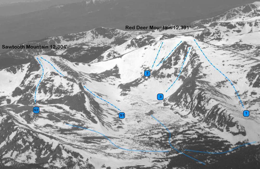
Red Deer Mountain and Sawtooth Mountain from the east (S1 and S2 are the routes on Sawtooth). Photo: Rob Writz
Route 3 - Red Deer Couloir
- Rating: III D10
- Season: Spring
- Exposure: Southeast
- Vertical: 1,000'
- Approach Elevations: 9,160’ – 12,391’
- Approach Distance: From Coney Flats TH 6.6 miles
The Red Deer Couloir is the prominent chute in the mountain’s Southeast Face that catches your eye when you crest the hill on Highway 36 west of Louisville. The couloir is not very long in length, and if you come all the way out here to ski it you should also check out the East Face or Sawtooth. The chute is a standard Colorado southeast facing couloir: early sun hit, steep at the top, several rock features exposed at the top, and rock walls on both sides near the narrow bottom. Good stuff! Ski this one early in the day due to the direct sun exposure, and ski it in the spring before it melts away. Follow the directions for the Southeast Face and the Red Deer Couloir is just before the Face on the right.
+ TRAILHEAD
There are two trailheads that can be used to access Red Deer Mountain: Coney Flats Road, or the Buchanan Pass Trailhead. Either trailhead works fine, but we prefer the Coney Flats entrance earlier in the spring for all of these routes, and for the Southeast Face routes at any other time. This trailhead is 460 vertical feet higher than Buchanan Pass Trailhead and may hold snow longer to allow for a ski approach.
Coney Flats Road Trailhead (9,160’)
From the Peak to Peak Highway (72) between Peaceful Valley and Ward, go left on County Road 96 2.4 miles to Beaver Reservoir. Follow the road around the north side of the reservoir 0.4 miles to the trailhead on your right. Park off of the road. If you have a high clearance rig and the road is snow free you can slowly grind (it might be faster to walk) 3.2 miles to the Beaver Creek Trailhead and Coney Flats.
Camp Dick Trailhead (8,700’)
The Camp Dick Trailhead is accessed off of the Peak to Peak Highway (72) at the big curve at Peaceful Valley. Drive west on this road (92) about one mile to the Camp Dick Campground. If you don’t have a high clearance rig and the patience for a slow and bumpy drive, leave your car here. Hike, bike, or off road this rough road 3.6 miles to the Middle Saint Vrain Trailhead.
+ MAPS & PICTURES
Below we have included a link to a Google interactive map and a curated list of photos of the mountain.

Clicking on map above will open interactive Google map website