Dry Gulch and Mount Trelease
Dry Gulch from the Northeast. Photo: Rob Writz
Mount Trelease and Dry Gulch are popular backcountry ski areas that are easily accessible from Interstate 70. You can get a good view of the Boulevard on Mount Trelease when driving up and down Loveland Pass. The terrain in Dry Gulch is not visible from any road and you need to skin or snowshoe in to access this area.
Although this area is highly accessible, it is very dangerous. The Boulevard appears benign, but it sits below the Pat’s Knob bowl. There are telltale signs of infrequent, but massive avalanches that can start in this bowl and sweep down the Boulevard. In Dry Gulch the terrain is comprised of northeast facing glades and gullies that are bisected all winter by cross loading winds. This cross loading has resulted in at least one fatality and numerous accidents. There was an old fire in this area leaving the forest exposed to the cross loading. During times of high winds there can be extremely shallow windward terrains, with cross loaded avalanche conditions waiting on the leeward side of the gullies. Be careful in here!
The entirety of Mount Trelease is in the Loveland Ski Are special use permit. Although Loveland is not using this terrain at this time, the most recent Loveland master plan calls for guided backcountry and snowcat tours in this area.
Finally, Mount Trelease is the site of the tragic 1970 Wichita State Football team plane crash. The ruins of the plane crash are on the lower flanks of the mountain. If you encounter these ruins, please be respectful of this site.
Interested in more winter backcountry skiing around Loveland Pass? Check out our guidebooks available on Rakkup and Beacon Guidebooks.
+ ROUTES
Dry Gulch and Mount Trelease
- Season: Winter
- Summit Elevation: 11,800’
- Aspect: Southeast, East, Northeast
- Elevation Range: 10,700’ – 11,800’
- Vertical: 800’
- Snowmobile Access: There is no snowmobile access in Dry Gulch.
Skin Track:
There are two approach choices for this area. To access the Boulevard area there is a skin track climbing directly up the steep hill from the trailhead and north into the forest. This climbs up and across the steep and often thin slope above the cars. The skin track then climbs to more open Boulevard area and up to treelike.
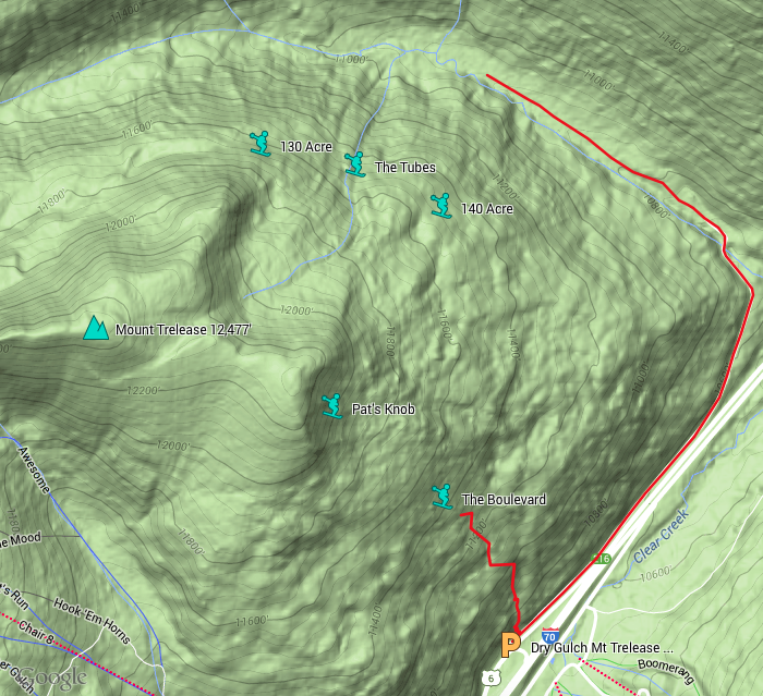
There are two ways to access the Dry Gulch terrain. One way is to climb the skin track described above to the Boulevard and then traverse north across treelike to a point to drop into the 140 and Tubes zones. A small rocky knoll at the north end of Pat’s Knob marks this. [39.6941, -105.8919] The other option is to depart the trailhead northeast on the frontage road next to the westbound lanes of Interstate 70. Follow this approximately 0.6 miles to a gate. Go around the gate and the road begins climbing north and then northwest into Dry Gulch. From the gate ski approximately 1.1 miles past the fenced in yard, past the clearing, and to the bottom of the 140, Tubes, and 130 areas. There are usually several skin tracks climbing from here into these zones from the valley floor. [39.7031, -105.8872]
Exit:
To exit the Boulevard area, ski to the bottom of the open glades and when the tree terrain becomes steep and dense, traverse skier’s right to the original skin track. Ski back to the trailhead along this skin track. If you continue into the steep trees you will end up on the frontage road used to access Dry Gulch. The road cut above the frontage road is frequently thin, rocky, and slide prone.
If you are in the Dry Gulch valley, follow the tracks in the valley floor back to the road, and to the gate on along the interstate. If you are parked near the Loveland Pass exit you will need to hike or skin back to the car from here.
Routes:
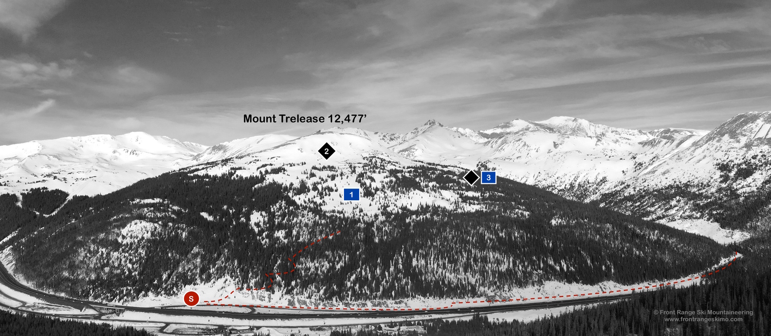
1 - The Boulevard – This is the large gladed tree terrain on the southeast flank of Mt Trelease.
2 - Pat’s Knob – This is the large bowl above the Boulevard. This should be skied in spring under consolidated snow conditions.
3 - 140 Acre – 140 is a broad area of gladed terrain east of the Tubes.
4 - The Tubes – The Tubes are several gullies descending from tree line on Mt Trelease.
5 - 130 Acre – 130 is the gladed terrain west of the Tubes. Like the Tubes and 140 this terrain has numerous ridges and gullies that are conducive to cross loading and leeward avalanche hazard.
+ TRAILHEAD
Dry Gulch (10,700’)
The Dry Gulch Trailhead is located at Exit 216 on Interstate 70. This exit is the same exit for Loveland Pass, the Loveland Ski Area, and the last exit before the Eisenhower-Johnson Tunnels. If you are exiting the interstate from the east the trailhead is immediately on your right. If there is a lot of snow you will park in a pull off to the right just before the off ramp goes under the interstate. If there is not snow you can continue northeast through this pull out on the dirt frontage road to the gate at Dry Gulch. This is next to the eastbound lanes of the interstate, and there is no official Forest Service trailhead here. If you are coming from the west, exit the interstate, and take a left on to Highway 6 and then an immediate left under the interstate. Look for the pull out described above on the left. [39.6859, -105.8863]
+ MAPS & PICTURES
Below we have included a link to a Google interactive map and a curated list of photos of the mountain.

Clicking on map above will open interactive Google map website