McClellan Mountain 13,587'
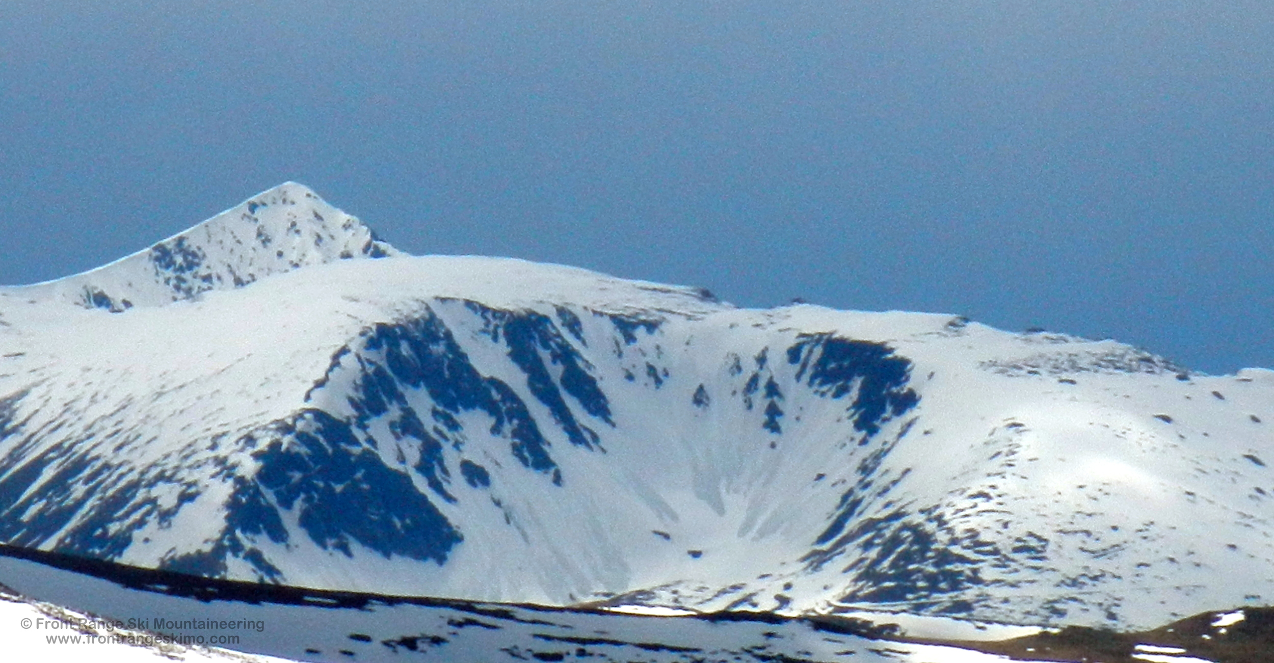
Santiago Bowl from the east. Photo: Rob Writz
The summit of McClellan Mountain is a high flat point on the long ridge that contains Ganley Mountain, McClellan, and Mount Edwards. This ridge runs north to south and it is the east wall of the long glacial valley that runs from Grays and Torreys Peaks to Bakersville. The west side of this ridge holds numerous couloirs and chutes, the majority of which are stripped bare by the winds of winter. During upslope storms these couloirs can fill in, and several can provide steep climbs and descents. Most notable is the North Couloir of McClellan Mountain that departs Stevens Gulch and arrives near the top of the east facing Santiago Bowl. The Santiago Bowl holds several enjoyable ski descents in a classically shaped cirque. The glaciers of the last Ice Age certainly left their marks on McClellan Mountain. Mankind has also left his mark on McClellan and this is evident in the various mines that litter the Leavenworth Valley including the Santiago Mine and the ghost town of Waldorf. McClellan Mountain is worth a trip. It is a long haul from the Leavenworth Creek valley, but the views from the summit of the Grays-Torreys-Edwards ski mountaineering paradise are worth the effort.
+ ROUTES
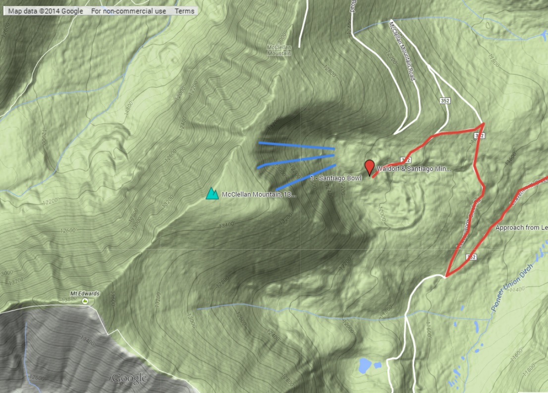
Route 1 - Santiago Bowl
- Rating: III D12
- Season: Spring
- Exposure: Northeast, East
- Vertical: 1,200'
- Approach Elevations: 9,500' - 13,200'
- Approach Distance: From Leavenworth TH: 7.8 miles
McClellan Mountain’s Santiago Bowl is reminiscent of the high cirques of Northern New England. It is a classic cirque shape located high above a long glacial valley. The leeward aspect of this bowl catches significant snow that is stripped off of the west side of the mountain. The bowl itself has several lines to choose from. The descents are surprisingly steep with angles in the mid-40 degrees, and several chutes are lined with rock walls. To fully leverage the effort that it takes to reach this bowl, we recommend that you combine it with a trip up Mount Edward’s East slopes to the south for a full day.
Depart the start of the Leavenworth Road at the trailhead description above. The first mile of the road is steep, crosses Leavenworth Creek, and reaches the old railroad grade around 10,000’. From here the road is straight forward and takes a mellow line southwest through the Leavenworth Creek valley. The low angled terrain above 11,000’ and several jeep roads in the area allow you to cut off the main road and follow snow towards Waldorf if a short cut is needed. It is 6 miles to the sharp switchback heading north at 11,594’. This is near the Waldorf Mine and the road continues south towards Mount Edwards and Argentine Peak. Follow the old railroad line north and then west to the ghost town of Waldorf, the Santiago Mine, and the Santiago Bowl. It is approximately 7.25 miles to this point from the Leavenworth Creek Trailhead. You can climb the bowl’s chutes from here or continue along the railroad grade north of the bowl to 13,117’ about seven tenths of a mile north of the summit. If you are able to snowmobile the approach or drive in the summer then the commitment grade of this route reduces significantly.
+ TRAILHEAD
Leavenworth Creek Trailhead (9,500’)
The Leavenworth Creek Trailhead is located at a major switchback on the Guanella Pass Road 2.5 miles south of Georgetown. The Leavenworth Road departs the Guanella Pass Road on an acute and steep angle. There is parking on the north side of the Guanella Pass Road switchback. Early in the spring you will need to park here and either ski or use a snowmobile to access Leavenworth Road. In the late spring and summer, depending on the amount of snow on the road in the forest, you may be able to drive a high clearance four-wheel drive vehicle towards the ghost town of Waldorf.
+ MAPS & PICTURES
Below we have included a link to a Google interactive map and a curated list of photos of the mountain.
Clicking on map above will open interactive Google map website