Saint Vrain Mountain, 12,162'
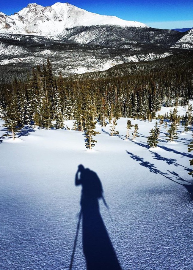
Saint Vrain Mountain Overview from the East. Photo: Rob Writz
Saint Vrain Mountain is a great place to ski early in the spring and to get excellent views of Wild Basin, the Saint Vrain Glaciers, and the Continental Divide north of Mount Audubon. The wind on Saint Vrain Mountain is omnipresent. A great skimo tour for earlier in the winter is to ski up Road 116.1 to the Saint Vrain Mountain summer trailhead, up Meadow Mountain, up Saint Vrain Mountain, and down the East Ridge to Forest Road 116 to the car.
+ ROUTES
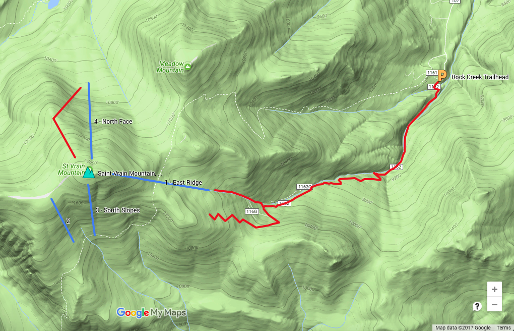
Route 1 - East Ridge
- Rating: II D2
- Season: Spring
- Exposure: East
- Vertical: 1,000’
- Approach Elevations: 8,680' - 12,162
- Approach Distance: From Rock Creek Trailhead: 4 miles
The East Ridge of Saint Vrain Mountain is more of a face than a ridge. This broad descent has many options and can be a long descent to the choke point in Rock Creek (up to 2,000’ if conditions are right). When you reach the narrow point of the creek with steepening walls on either side (around 10,400’) head east into the forest to regain road 116. Feel the burn down the road to the car.
From the Rock Creek trailhead, take the left fork south up Forest Road 116.2 for approximately 2.5 miles to tree line. There are several variations to the 116 road and you will end up either in the bowl below the East Ridge or on the shoulder east of the East Ridge. From either point continue straight to the summit.
Routes 2, 3 - South Slopes
- Rating: II D4
- Season: Spring
- Exposure: South
- Vertical: 800' - 1,000'
- Approach Elevations: 8,680' - 12,162'
- Approach Distance: From Rock Creek Trailhead: 4.5 miles
The South Slopes can easily be combined with the East Ridge for a longer ski day. The broad snowfield (2) accessed from the west plateau at 11,800' is more reliable than the direct line below the summit (3). Follow the approach for the East Ridge to the summit of Saint Vrain Mountain. The direct south slopes (3) are accessed via a quick scramble over rocks from the summit to the southwest. To reach the more reliable line originating at the plateau (2), continue west from the summit for under a half mile the top of the snowfield at the broad bench at 11,800'. Ski the South Slopes to tree line and climb back up the descent route to the summit.
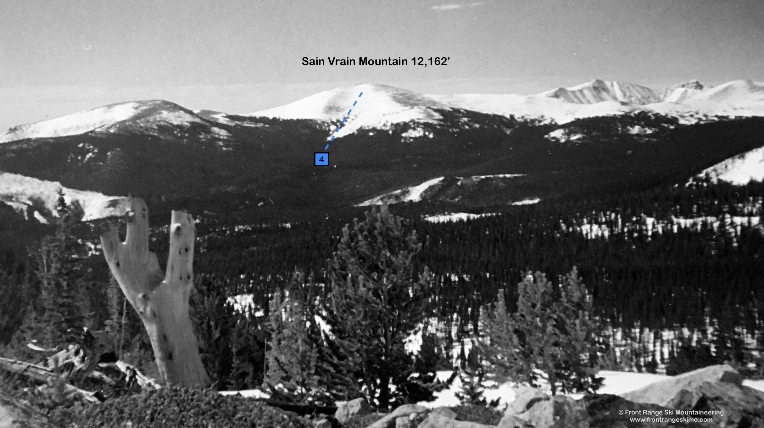
Route 4 – North Face
Andy Hansen has contributed Saint Vrain Mountain’s North Face description. Andy is a Colorado Mountain School Guide, and you can see pictures of Andy’s adventures on Instagram under the handle rock_warrior. In the summary below, he describes a 10 mile and 5,000’ vertical day on the North Face.
- Rating: III D4
- Season: Winter, Spring
- Exposure: North
- Vertical: 1,500’
- Approach Elevations: 8,870’ - 12,162'
- Approach Distance From Rock Creek Trailhead: 4.2 Miles + 1.2 Miles to Climb North East Ridge
The North Face of Saint Vrain Mountain has a distinct remoteness compared to the East Ridge. The City of Longmont and the Eastern Plains are visible to the east, while the view from the North Face peers into Rocky Mountain National Park’s Wild Basin. The views into the Basin are inspiring and this is an excellent vantage to use to plan excursions into the south side of Longs Peak. Massive Copeland Mountain and its big East Face lie to the west.
A rounded northwest trending ridge creates a leeward snow deposit on the Face harbors the North Face of Saint Vrain Mountain. This can result in the North Face holding wind blown powder and a 1,500’ drop into the forest below. From the summit, the line is fairly obvious as it descends directly north into an avalanche path. The slope angles are around 30 degrees, and there are some simple hazards to avoid. Namely these are two convex rollovers mid-pitch on either side of the descent. Once you reach the flatter and dense trees at the bottom it is time to climb back up: gain the blunt Northeast Ridge of Saint Vrain Mountain and climb this back to the summit.
Approach the North Face from Rock Creek Trailhead. Follow the approach described for the East Ridge. A direct alternative on this approach is to enter the Rock Creek drainage after approximately two miles. At this point there is a sharp switch back to the left, and you may notice a faint path to the right with orange flagging on the trees. Go right into the creek drainage, and proceed up Rock Creek and climb to the summit via the East Face.
+ TRAILHEAD
Rock Creek Trailhead (8,680’)
The Rock Creek Trailhead is accessed from the hamlet of Allenspark that is located on Route 7 south of Estes Park and north of Ward. Turn into the town of Allenspark at the west entrance from 7, go several hundred feet south past Allenspark Community Church, take a left on 2nd and then a right onto the narrow, curving, and sometimes one-way Ski Road. Proceed about just over a mile to the 116.1 and 116.2 fork. Park here.
+ MAPS & PICTURES
Below we have included a link to a Google interactive map and a curated list of photos of the mountain.

Clicking on map above will open interactive Google map website