Uphill Access at Loveland Ski Area

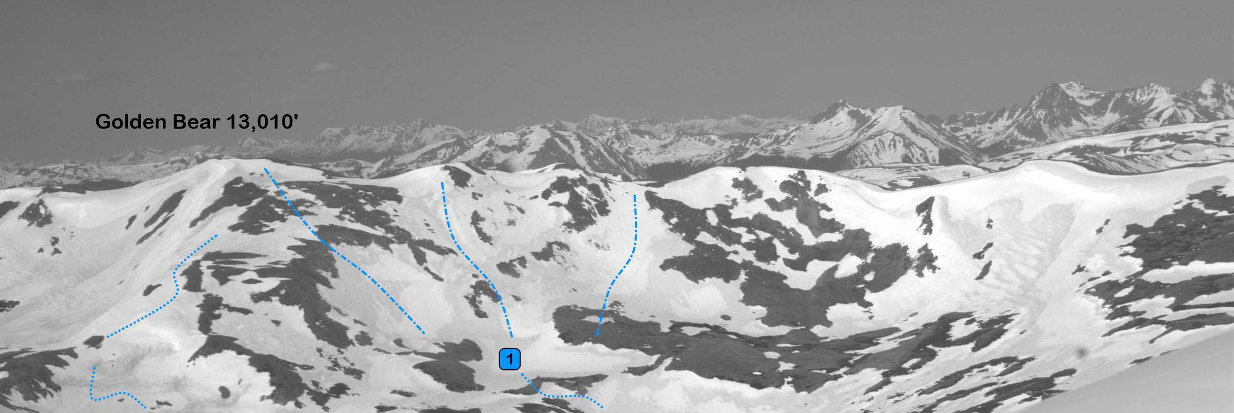
There are few close opportunities for uphill skiing at a Front Range ski area. The two prominent resorts for uphill skiing are Loveland and Arapaho Basin.  There are also uphill opportunities at Winter Park, Keystone, and Breckenridge. Skiers and snowboarders use uphill access at the ski area for numerous purposes. The relative safety of the ski area allows uphill skiers to earn their turns in an environment with less avalanche and snow hazards, the exercise is great, and the views are phenomenal.

The uphill scene at Loveland is more laid back than the uphill scene in Summit County. The skiers and snowboarders going uphill at Loveland seem to be of the more recreational variety and less of the skimo racing type. Snowshoers even enjoy the uphill access.

Loveland’s uphill access has several advantages over the Arapahoe Basin uphill. First, Loveland is closer to the Front Range cities than A-Basin. This is really helpful for an uphill ski in the morning before a powder day in winter. Second, Loveland’s uphill access is open before, during, and after the ski area’s operating hours.

Unlike A-Basin, Loveland restricts the uphill access to two routes. Both routes launch from the base area at Chair 2. There is a sign posted at Chair 2 noting the A and B routes. A and B route share the same path on Tango Road until the split at Turtle Creek and Lower Creek Trail. There are occasional signs on the way up each route noting A or B.

Route A goes to the top of Chair 2 and Ptarmigan Roost. After the ski area opens for the day the Ptarmigan Roost is accessible and a great place to warm up and transition for the downhill. This is especially nice in the winter as the winds can howl at Loveland. Route A is an easy and quick uphill and is open most of the time. It is easy to get confused as to which run is North Turtle Creek and South Turtle Creek and we have seen uphill skiers on both runs. Loveland asks you to stay on North Turtle Creek.

Route A Summary:

  • Length: 1.46 miles
  • Vertical Gain: 1,191’

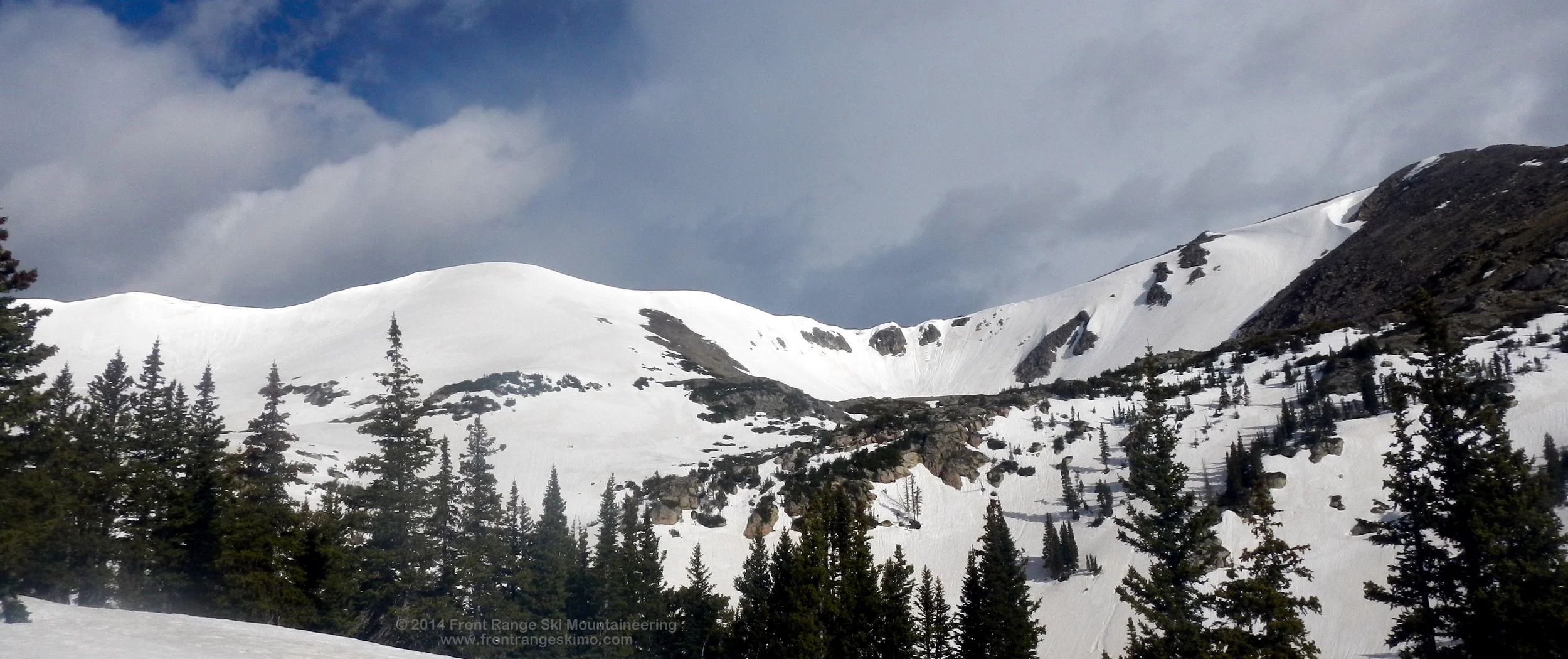
Route B is a much longer climb to the Continental Divide and the top of Chair 9. After the A/B split this route continues up Lower Creek trail and past the bottom of Chair 9. There are occasional “B” signs going up, but the left turn up Rookie Road is not signed well. This route is frequently closed for snow safety operations.

Route B Summary:

  • Length: 2.08 miles
  • Vertical Gain: 1,907’

Please review Loveland Ski Area’s uphill access policy and map at their website. This web page gives Loveland’s expectations for uphill access as well as the conditions for when the access is open or closed. You need to go into the season pass office to get a free uphill access pass prior to your first uphill. The Loveland Ski Patrol frequently checks for this pass when you are climbing up.

As we enter into the final month of Loveland’s season, the uphill access can be a great addition to a spring ski day. Perhaps a morning skin up while you wait for the conditions to defrost for corn skiing? The views are great and the access is a snap. We highly recommend an uphill jaunt at Loveland!


Dave Dombrowski skis up the "B" route to the Continental Divide and Chair 9.

Dave Dombrowski skis up the "B" route to the Continental Divide and Chair 9.

Moderate Peaks to Climb for Assessing Spring Conditions

Spring is upon us in the high country!  The days are longer, the snowstorms are gaining moisture content, and the Front Range ski lines that were windswept all winter are starting to fill in.  It is time to get out there and higher than you have all winter!

With the excitement of spring comes a hesitation: what is the snowpack like?  This is a complicated time due to varying conditions during the isothermal transition.  The south and east faces are turning to corn, west faces still have breakable crust, and the north faces may be harboring winter conditions including persistent slabs.  This is a challenging time to assess the snowpack.

We had several users email us on this topic and they asked for recommendations of peaks and routes to “safely” climb and ski, and be up high so they can get a sense of the snowpack.  We have included several recommendations below.

First, we recommend a review of Front Range Ski Mountaineering’s Conditions page.  Use this for a basic understanding of the dynamics occurring in the transforming spring snowpack.  Second, make sure to stay up to date on avalanche conditions and reports via the Colorado Avalanche Information Center.  Although it is spring there are still winter conditions in the snowpack!

Here are several recommendations for great peaks to ski during this transition period to get a sense of the conditions:

Saint Vrain Mountain is a peak that you can ski throughout the winter and spring with relative snow safety.  That is, if you can stand the wind!  The spring advantage for Saint Vrain is that it is not steep, it has South, East, and North aspects to explore, and it gives you a great view Mount Audubon, Sawtooth, Red Deer, Saint Vrain Glaciers, and Wild Basin in Rocky Mountain National Park.

Saint Vrain Mountain from the Northeast.  Photo: Rob Writz

Saint Vrain Mountain from the Northeast.  Photo: Rob Writz

In the James Peak Wilderness we highly recommend the Southeast Flank of James Peak and Frosty Mountain.  We haven’t posted James Peak to this website (yet), but we have included a picture below.  James Peak is quickly accessed from the Saint Mary Glacier on the Fall River Road.  It is an easy climb to the summit and the views include the South Boulder Creek Drainage (Heartbeat Peak, Frosty), and the North side of Mount Bancroft. 

James Peak from the top of Saint Mary Glacier.  Photo: Rob Writz

James Peak from the top of Saint Mary Glacier.  Photo: Rob Writz

Frosty Mountain is a classic that sits on the Continental Divide between James Peak and Rollins Pass.  It is a longer excursion than Saint Vrain and James Peak, but it is a moderate descent and the approach allows you to inspect the North, East, and South facing aspects in the bowl surrounding Frosty.  The east-facing descent directly from the summit of Frosty into the basin should be getting primed with corn conditions now.

Frosty Mountain as seen from the approach from Moffat Tunnel.  Photo: Rob Writz

Frosty Mountain as seen from the approach from Moffat Tunnel.  Photo: Rob Writz

Golden Bear, or 1310 as the Loveland Ski Patrollers call it, is a great peak for early spring ski descents.  Golden Bear has slopes of varying steepness and exposure including North and East.  The tour up Dry Gulch will allow you to inspect the South side of Citadel and Hagar Mountain.

Golden Bear from the South.  Photo: Rob Writz

Golden Bear from the South.  Photo: Rob Writz

Finally, we recommend Cupid from Loveland Pass.  The Southeast Face is a moderate ski descent and has been cooking in the sun the past month.  The climb back up the basin to the Continental Divide and the summit of Cupid is an easy skin.  You can ski Dave’s Wave to the highway near Arapahoe Basin, ski the various chutes facing south to the switchbacks below Loveland Pass, or hike down the ridge to Loveland Pass.

Cupid from the East.  Photo: Rob Writz

Cupid from the East.  Photo: Rob Writz


Front Range Conditions June 22

Happy Summer Solstice! There is still a lot of snow up in the hills. With the opening of the Brainard Lake Road we sent the Front Range Skimo R&D team deep into the Indian Peaks to see what the conditions are like.  Here is what they found:

The Brainard Lake Road is open past the gate at the winter trail head. Unfortunately the road is then closed just before Brainard Lake near the campground and the newly built day area. This means it is about a mile from the closure to the Long Lake TH and the Mitchell Lake TH. We went up the Long Lake TH and there are snow drifts still blocking parts of the parking lot. Those should be melted within another week. The snow on the trail starts almost immediately at the trail head, and there are several miles of constant snow drifts on the trail all the way to Lake Isabelle. The Pawnee Pass trail is covered in snow until above tree line on the plateau below the Pass and Pawshoni Peak. From there to the pass it is mostly a rocky dirt trail.

We saw a lot of tracks on Mount Toll. It looks great to ski still! The Pawshoni and Shoshoni Bowls are thinner and discontinuous. The middle and right Keyhole Couloirs are still in. Apache Couloir is still in, but not connected to the summit. It is connected all the way to the ridgeline, though. Queens Way is in and still connected to the summit. The Navajo Snowfield looks great, and steep! Pawnee Peak is a rock star. The Pawnee Couloir is in and looks like it will be around for awhile. We have posted a few pictures below.

On the west side of the Continental Divide the North Couloir of Pawnee Peak is in great. Lone Eagle Cirque is amazing and every route is still in condition in this vast and remote area. The lower apron of the Hopi Glacier runs all the way to Crater Lake. The Fair Glacier is in immaculate condition, and Cherokee’s Northwest Chute is still continuous, and this is one of the first lines to melt out in the cirque.

Sunset on Pawnee Peak

Sunset on Pawnee Peak

Lots of snow in Lone Eagle Cirque.

Lots of snow in Lone Eagle Cirque.

Paiute is still looking good.

Paiute is still looking good.

Lots of tracks on Toll!

Lots of tracks on Toll!

Navajo Snowfield, Apache Couloir, and Queens Way are still holding snow!

Navajo Snowfield, Apache Couloir, and Queens Way are still holding snow!


Front Range Conditions June 15

The Front Range’s big winter of 2013-14 is finally paying off for spring ski mountaineering. Although the lower peaks are melting away, there are copious amounts of snow on the north and east faces of the high peaks. Also, the freeze has returned to the high country as well (at least for this weekend).

We sent the R&D team up Grizzly Gulch below Torreys and Grizzly Peak this weekend. A solid freeze on Saturday night resulted in good travel up the valley. We were able to drive to the Grizzly Gulch trailhead at the crossing of the stream exiting from Stevens Gulch. If we had a high clearance off road rig we could have continued driving through the three stream crossings to basin between Kelso and Torrey’s north face. Beyond here the jeep road is well covered in snow.

A massive avalanche released from the Emperor Couloir this winter and packed the valley floor with trees and snow. It may take all summer for this snow to melt. See below for some of the pictures.  

We saw several skiers on Torrey’s Tuning Fork, and reports from the Emperor Couloir is that the top did not defrost by normal ski descent time. The Grizzly Couloir is ready to go. We explored further up the valley and had great descents on the East Face of Cupid and the North Slopes of Grizzly.

On Friday we were able to get several high vantage points and catch a glimpse of what was still out there. All aspects of Torrey’s peak are in, the North Face of Evans looks great, the Continental Divide north of Loveland looks really good for this time of year (Golden Bear, Hagar, Citadel), and the various couloirs and bowls along Continental Divide between James Peak and Rollins Pass are in.  Queens Way on Apache is in good form, The Pawnee Couloir looks solid, and the terrain around Blue Lake is skiing well.  We saw ski tracks in the dust layer on Radiobeacon, Sawtooth, and a few other

This is less than half of the debris field. It is about 400 yards wide and debris goes about 50 yards into the forest.

This is less than half of the debris field. It is about 400 yards wide and debris goes about 50 yards into the forest.

Jackstraw debris.

Jackstraw debris.

Moonset over the Grizzly Couloir.

Moonset over the Grizzly Couloir.

Torrey's Tuning Fork looks great!

Torrey's Tuning Fork looks great!


Front Range Conditions June7

The spring snowpack is rapidly changing to a summer snowpack. It is a good thing the Front Range had a significant snow this winter, otherwise the snow would be gone. Given that the transition to summer is occurring rapidly we sent the R&D team to the high peaks.

We spent the day of June 8 in the Guanella Pass area. The peaks surrounding this pass are high thirteeners or fourteeners and hold summer snow. The Front Range Ski Mountaineering R&D team spent the majority of the day on Square Top, Argentine Peak and in the Leavenworth Creek and Naylor Lake drainages. The East Face of Square Top, the Southeast Bowl of Argentine Peak, and the Northeast Face of Argentine Peak are all holding snow and good lines. The views from the Continental Divide in this area are spectacular and reveal good looking snow in the Santiago Mine Bowl on McClellan, the south facing snowfields of Edwards, and the east facing lines of Grays and Torreys. The north facing couloirs on Square Top are not connected from top to bottom. The Northwest Bowl of Bierstadt is still skiable from several hundred feet below the summit.

The Silver Dollar Lake Road still has snow drifts and downed trees that required parking at the Guanella Pass Road. The Silver Dollar Lake trail is heavily snow covered. The chutes that drop down from the north side of Square Top have deeply buried the trail, and in the forest between the trailhead and Naylor Lake there is deep and consistent snow. The trail opens up above tree line and away from the chutes. We spent a portion of the morning on the snowless Mount Wilcox. Although snow was the objective, the dry terrain of Wilcox made for easier travel up and down the valley.

A freeze occurred on the evening of June 7 which allowed for more rapid travel than in weeks past. A hard freeze most certainly occurred on the evening of June 8. This has been the challenge this spring. No hard freezes. They were absent most of May and have returned in the past week. It looks like temperatures will warm up again and these freezes will go away.

The thunder snow returned and a heavy snow storm hit the area around 11 am. This time lightning was mixed into the equation, leading to a tense descent off of Argentine Peak! This storm was a hundred times for volatile than the one that hit us on Frosty the week before.

Front Range Conditions June 1

The "tweener" weather continues. Its not too hot on the Eastern Plains, and not cold in the Front Range Mountains. The temperatures at the high passes continue to stay above freezing. This is resulting in rapid melting and a lack of stability on steeper slopes.  

We sent the Front Range Ski Mountaineering R&D team to the Moffat Tunnel to explore the conditions. They were able to begin consistent skinning towards Frosty and Radiobeacon just pass the intersection of the Forest Lakes Trail and Arapaho Creek. A burst of thundersnow at 8 am on the Continental Divide resulted in an immediate ski down Frosty and off the divide. The snow on Frosty had not frozen and even at 8 am the conditions were grabby. 

Time to start exploring the darker north faces and west faces to see if they are holding better conditions. Be careful out there.

Our Use of the D Scale for Ski Mountaineering Routes

We use the “D System” to describe several factors for the Front Range ski mountaineer to consider when thinking about a route. The D System is comprised of three parts and is fully described on Lou Dawson’s Wild Snow website. Please refer to the Wild Snow website for a description of the D System, and further dialogue on how it is used. Our website describes the D System in the context of other information provided on our “How to Use This Website” page.  

In some ways we are challenged with the D System. It is hard to place an assignment on a ski descent that is a constantly transforming medium. As Lou Dawson indicates on his website, we are trying to use this to show the normal difficulty, hazard, and commitment found during the time when the route is most likely to be skied. For the Front Range that is between late April and the end of June, with a few exceptions. We snowboarded the Dead Dog Couloir in June during the drought year of 2002 and found it to be far more difficult than D12 rating it frequently gets. There were steep runnels throughout the chute and it was steeper than normal. This is certainly not the normal conditions for the route.

The Dead Dog Couloir is a good example of a Front Range route that is skied so frequently that most agree on the D12 rating. It could be D11. It could be D13. The Front Range ski mountaineering community is honing in on D12 due to this route being known to many. On this website we describe many routes that are not frequently skied. If you feel that a route should be rated harder or easier please let us know. We expect to true these ratings with user feedback over time.

Our biggest challenge is using the “Risk” scale. The Risk Scale is not used frequently on this website. This website considers every ski ascent and descent to be inherently risky. These objective hazards are encountered on every ski descent in this website, and these hazards can vary by season. Fundamentally, all of the routes described in this website are dangerous and are at minimum R1 on the risk scale. Because these routes are all subjected to some form of objective hazard, we reserve the R rating for routes that require a risk rating that is more significant than the normal risks encountered (R1).

We find the use of the D System by many Front Range ski mountaineers so we will use this system for now. The goal here is to give you a sense of how challenging the route is in relation to others, and this is another piece of information to be used in your toolbox. Don’t let the D System assignment replace your assessment of conditions. You, your companions, and Mother Nature will dictate how challenging the route really is. 

Front Range Conditions: Memorial Day Weekend 2014

This Memorial Day Weekend was not as kind as holiday weekends from the past years. Clouds dominated the Front Range evenings and prevented a freeze. Evening temperatures at Loveland Pass and Rollins Pass did not break freezing. Thunderstorms kicked up every afternoon. It even snowed a bit.

Despite these challenges we sent the Front Range Ski Mountaineering team into the peaks on Memorial Day and Tuesday, May 27. Here is what they found:

Memorial Day: The R&D team worked their way up the Rainbow Road, just off of the Fall River Road, to Mount Eva and Witter Peak. They were able to drive past 10,225’ on the Rainbow Road, and high clearance 4WD could make it to a quarter mile before the Chinns Lake Road intersection. It wouldn’t matter as this intersection is on private land and there is no parking here. Parking is back at the Continental Divide Trail at 10,225’. Consistent skiing began at the Chinns Lake Road intersection. The Rainbow Road had sporadic snow, but skinning could be had in the adjacent forest. The Chinns Lake Road is snow covered the whole way and awkwardly out sloped.

The fresh snow from Sunday night made Perry Peak look like a good ski descent, but the R&D team knew better than to trust that lurking boneyard. The upper bowls of Eva and Witter were stocked full of snow. Even though a deep freeze did not occur, and the 2 to 3 inches of new snow insulated the under layers, the low angled bowls of this beautiful and under utilized basin skied great. The Welcome Couloir on Witter looked unwelcoming as a lot of loose wet slides had barreled through the couloir and left a bumpy channel in the lower half of the couloir and debris piles in the run out. The face above the couloir still looks good, though.

Tuesday: We sent the R&D team to the Mount Evans Road to scope out conditions on the road and sample the food at the Echo Lake Lodge. Word from the Echo Lake Lodge staff is that the Mount Evans Road was closed consistently through the weekend.  The road opened at 1 pm on Tuesday once the fresh snow had melted (open to Summit Lake). After some chili and club sandwiches the R&D team headed up. They report that the routes around the Summit Lake Bowl look great. The Sunrise Couloir and the steep routes on the South Face of Mount Spalding have some loose surface slides that could freeze into coral reef, but for the most part they are clean. The cornices above these routes are massive. The North Face of Mount Evans is full of snow. The Northeast Face look like crap: rock fest. The East Face (just south of the Northeast Face) looks spectacular and ready for big banking turns.

Check out the Twitter handle @frskimo for some landscape pictures of this weekend.

Front Range Conditions: Weekend of May 17

The Front Range’s spring ski mountaineering season is in full effect. 

What, spring you say? 

Yes, spring. 

But it is almost June!

That is correct. It is almost June, but winter is just now moving out of the Colorado high country. Last week the Arapahoe Basin ski area received nearly 40 inches of snow. According to the article by the Daily Camera, the snowpack in the South Platte River Basin had been 121 percent of average, but after the snow fell over Mother’s Day weekend, that number reached 145 percent.   

With all of this snow fall, we sent the Front Range Ski Mountaineering R&D team to the peaks to see how the new snow was settling in.  Here is what we found:

Saturday: A trip up the Stevens Gulch area near Grays and Torreys Peaks revealed that you won’t be able to drive past the first switchback before needing to park. The snow blocks the road from cars and trucks at this point (for now).  We walked on intermittent snow and dirt to the fork with the Grizzly Gulch Road, and then skied on skins up the remainder of the road. The temperatures were warm down low and a full freeze did not occur.  The clouds from the night before prevented this, and there were several loose slide releases during the day.  It was hot spring conditions below tree line and winter above tree line.  Reports from Kelso’ North Couloir was that the top was chalky powder and slush at the bottom of the gully. A skier triggered wet slab late in the day on a northeast aspect below tree line on Ganley Mountain originated from a single turn that slid on the dust layer and ran about 500 vertical feet (R3, D2).

Sunday: A clear night resulted in a deeper freeze and the newer snow beginning to bond to the older snow.  Front Range Skimo R&D explored Herman Gulch and discovered intermittent snow immediately on the trail. Skinning began near the flats at approximately 10,800’. The basin was active and there were obvious loose slough slides on the north side of Citadel, and it appears these slides prevented skiers from descending the Northeast Couloir (Snoopy’s Backside).  Larger natural wet avalanches occurred in the basin during the day. There was a freeze, but it got hot fast.  Word from the Gore Range is that the Silver Couloir on Buffalo was a “shit show” and that about 800 feet down the couloir small release (presumably occurring on Saturday) had widened into a large wet slide and mowed down the lower couloir leaving debris and heavy wet snow.  

Check out our Twitter handle @frskimo for some landscape pictures from this weekend. Be safe out there!

Welcome!

Welcome to Front Range Ski Mountaineering! Colorado’s Front Range is blessed with an amazing spring and summer ski mountaineering season that usually runs from mid-April to mid-June. Some permanent snowfields provide skiing opportunities into the summer. We soft launched the website in early May for Colorado Front Range ski mountaineers to get their hands on, use, and provide feedback. We hope that you enjoy using this site and we welcome your feedback, changes, new routes, and insights. Please see the contact page for more information on how to reach us.

This is a “where to” guide, not a “how to guide”. We provide information to help you identify and reach some of the best ski mountaineering descents on Colorado’s Front Range. Snow is a changing medium and we don’t know what you will encounter when you go. The trail may be snow covered all the way from the trailhead, or perhaps you are walking in hiking boots for several miles before you reach snow, who knows? The route may be filled with a ton of snow from a big winter and moderate the pitch, or it may be a drought year and the couloir is steeper than normal and littered with rocks and fluted ridges. We do our best to describe the route and approach at a high level during an “average” year at the common times for Front Range ski mountaineering.

Ski mountaineering is a dangerous activity. With experience and good judgement it can be a really fun and addictive activity. To develop that experience and good judgement we suggest that you get a mentor to guide you through the experience, mountains, skills, and equipment. There are also several excellent ski mountaineering guide services in the Front Range and these are listed on the resources page of this site.

We will be updating this site throughout the spring. There will be many more peaks and routes added during this time. We will tune the site based on user feedback and then have it really ready to go for the 2015 season. Watch for detailed updates on Twitter @FRskimo and for high level updates on this blog.

Thank you!

Front Range Ski Mountaineering